

The 2026 Fire Season is Already Catastrophic
And the NIFC's latest predictive outlook hints at a dangerous summer

This fire season is going to be terrible. It already is terrible. Fires have raged through Oklahoma, Texas, Florida, and now Nebraska, which has experienced its most historic fire season to date. In March. Most of the country is in drought and/or suffering from low snowpack, including the Southeast, which is gripped by historic drought.
We’re gonna get in the weeds here, so hang in with me.
In the midst of this, the National Interagency Fire Center recently released its National Significant Wildland Fire Outlook for March-June 2026.
From the first paragraph:
“Fire activity remained at low levels across the U.S. in February but increased modestly the latter half of the month. The most notable increase in activity occurred in the Southern Area, which increased its geographic area preparedness level to three (on a scale of 1-5) February 24.
Other areas that had more modest increases in activity were the Northern Rockies, Rocky Mountain, Southwest, and Eastern Areas. However, the National Preparedness Level remained at one (on a scale of 1-5) due to the low level of activity nationally and availability of resources. As of February 27, 385,991 acres have burned across the country, which is 422% of the previous 10-year average. So far this year 7,895 fires have been reported, also well above average, at 183%.”
Fires burned less acreage than usual in January 2026, but 2,909 fires were reported, ranking January 2026 third (since 2000) in terms of fire ignitions.
I am suspicious of these claims of “low levels” and “modestly increasing” fire activity. That’s clearly untrue given the high regional preparedness level and the absolutely bonkers 422% February increase of the previous 10-year-average, which accounts for February 2024.
Someone please tell me if I am misreading this.
According to their own records, 4,986 wildfires burned in February 2026, burning a total of 351,026 acres. The average February acreage burned is around 73,000. That’s
February 2026 ranks second for acres burned since the year 2000, yet NIFC called February fire activity low.
Compare this year’s report to the March 2024 NIFC report:
“Fire activity remained at low levels across the US at the beginning of February, but activity increased significantly across portions of the Rocky Mountain, Eastern, and Southern Areas the latter half of the month. The Eastern and Southern geographic areas increased to preparedness level 2 (on a scale of 1-5) on February 26 due to increased fire activity, with Southern Area increasing to preparedness level 3 on February 28, with dozens of large fires burning in the Southern Area at the end of the month. Year-to-date annual acres burned for the US is well above the 10-year average near 135%, but with a below average number of fires, near 92%.”
Note that as it stands, 1,403,830 acres burned in February 2024. This is far above the initially stated 135% YTD annual acres burned, which means numbers rose significantly after the initial reporting.
According to the mismatch between percentages listed and acres burned, it’s likely that this February will be proven worse than February 2024, once full measurements are confirmed.
Importantly, I’d like to point out some inconsistencies between some Energy Release Component (ERC) calculations and the National Wildfire Outlook.
According to the NWO, fire activity through June is expected to be normal in much of the United States, yet the ERC is quite elevated in many areas. In some regions records are no longer being recorded– likely fallout from the DOGE firings.
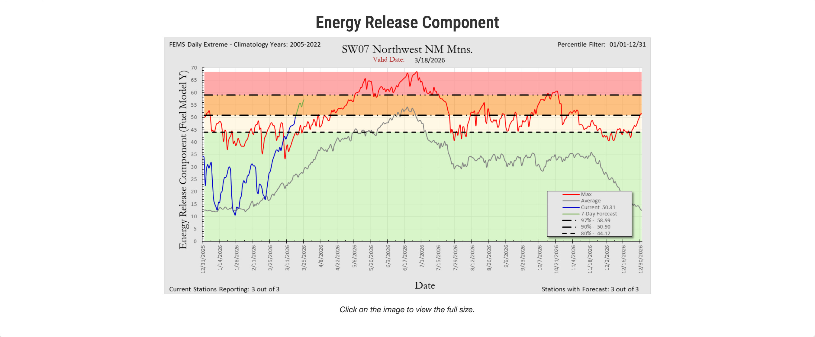
One example, above, is the current ERC rating for the Northwest New Mexico mountains. The red line indicates the recorded maximum. The gray line = average. And that little blue line? That’s current. Follow the little blue line until it rises above the red maximum. When the blue turns green that shows the seven day forecast. The line rises almost vertically, reaching ERC level maximums previously recorded in mid-May.
What does this mean? Well, think of the ERC as the potential intensity of a fire, based on fuel and soil moisture, drought levels, predicted weather. If a fire starts here, it will burn much more intensely than is typical for this time of year. Above what has previously been known as max intensity for the dates indicated.
It’s a bit baffling to me that the previously cited outlook clearly downplayed the forthcoming danger of the 2026 fire season. This season will, in my estimation, be worse than last year’s, yet last year’s language indicated a more dangerous fire season. My conclusion? There may be some censorship happening. But that’s just my opinion.
What About Drought?
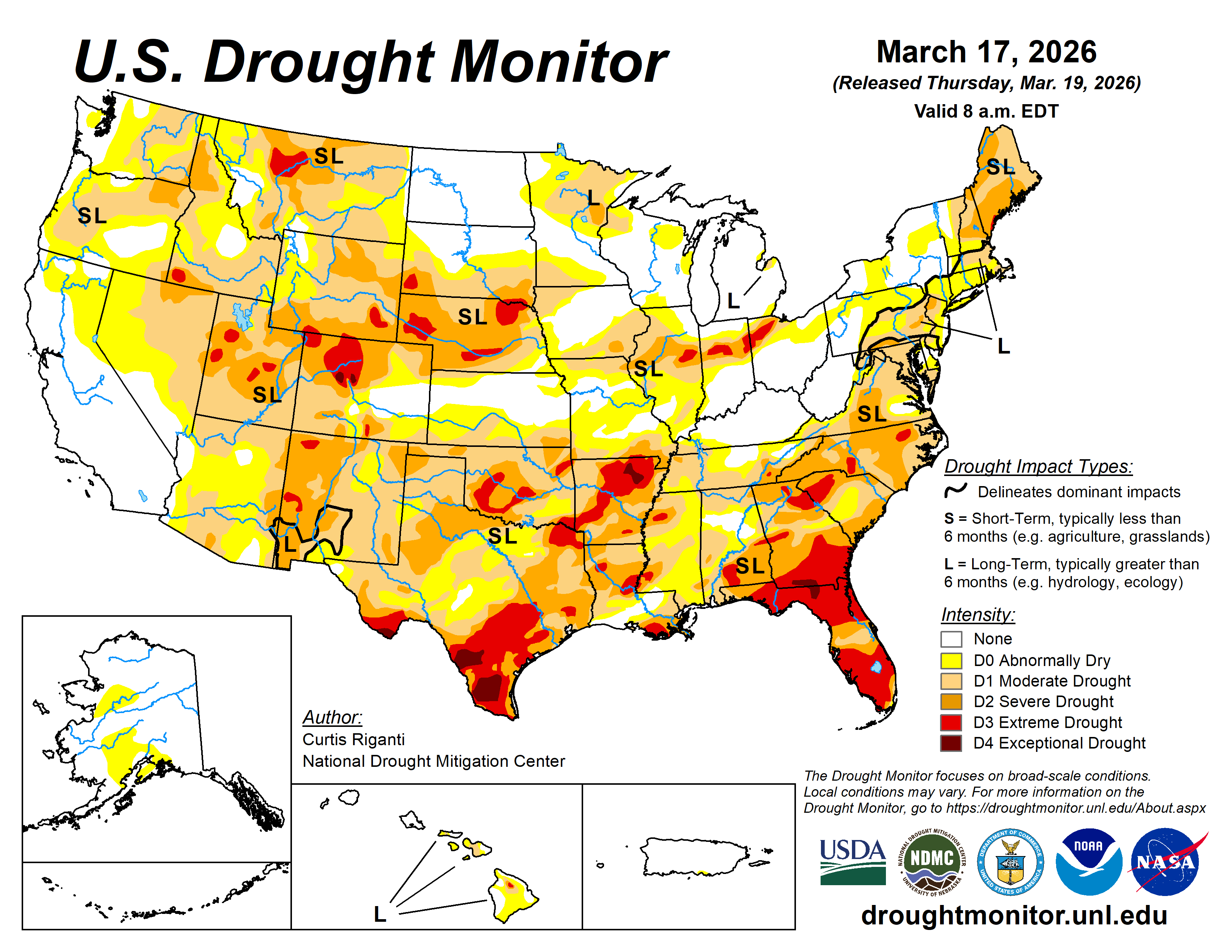
According to the U.S. Drought Monitor, over half of the United States is currently “abnormally” to “moderately” dry. This includes much of the northeastern U.S. as well as the south and southeast, both of which have large pockets of moderate to severe drought. I live in Tallahassee, Florida, and it hasn’t rained significantly in almost eight months. Very, very unusual. Notice the “S” and “L” on the map, which stand for “short term” and “long term.” It’s both.
While parts of California and the Pacific Northwest appear unaffected, this doesn’t account for the low snow pack. The Trump administration recently cut an important aerial forest health detection system in California– this is one of many cuts throughout the United States, which leave scientists, the public, and firefighters with unclear data regarding fire severity and ecological health.
“‘Our ability to detect emerging forest issues and address those challenges is going to be really impacted," said Michael Jones, a forestry adviser at the University of California Cooperative Extension program, who uses the survey data to inform his work consulting on bugs, disease and other forest management concerns. "We have no other program that can fill this need.’”1
According to the NOAA, California is undergoing a snow drought, incurred by unseasonably high temperatures.
Typically, snow begins to melt in May, but the California Department of Water Resources estimates that:
“California could experience the second-lowest April 1 snowpack in recorded California history. The lowest April 1 snowpack was in 2015, when the statewide snowpack stood at just five percent. April 1 is typically when we see our peak snowpack. This year that peak likely occurred in mid-February.”
I wrote about the impacts of low snowpack in my book (which you can buy here). Many people ask how snow and rain affect moisture. Why do we need snow if we have enough rain? Because snow melts into soils, permeating more deeply than rain, which skims over soil surfaces and drains into waterways. Heavy snowpack melting over longer periods of time can raise soil and plant moisture levels throughout summer, leading to higher fire resistance, particularly for heavier fuels like brush and trees. With adequate moisture, trees can withstand wildfires while the lighter, flashier fuels like grass, small trees, and light brush burn, clearing undergrowth, which leads to healthier forests.
This is why prescribed and cultural fire is so important to ecological health.
READ: Why Tending the Wilderness is More Protective than Abandonment.
Fire burns in Cross Creek, FL marshland and in Calhoun County, FL. Police deputy dies after helping with Florida wildfire evacuation.
Fire burning along Colorado 115 between Colorado Springs and Penrose 0% contained. Mandatory evacuations are in place.
Fire danger remains high in Oklahoma, evacuation orders lifted.
Successful ongoing prescribed burns in South Carolina.
County in Northeast Arkansas issues burn ban amidst high fire risk.
Boulder, CO has had more red flag warnings in 2026 than it did in all of 2025.
We are at a National Preparedness Level 2 out of 5.
The most active regions are the Rocky Mountain Area (PL 2), South Area (PL 2), Northern Rockies (PL 1) and Eastern Area (PL 1). It is highly unusual for us to be at a National Preparedness Level 2 as early as March.
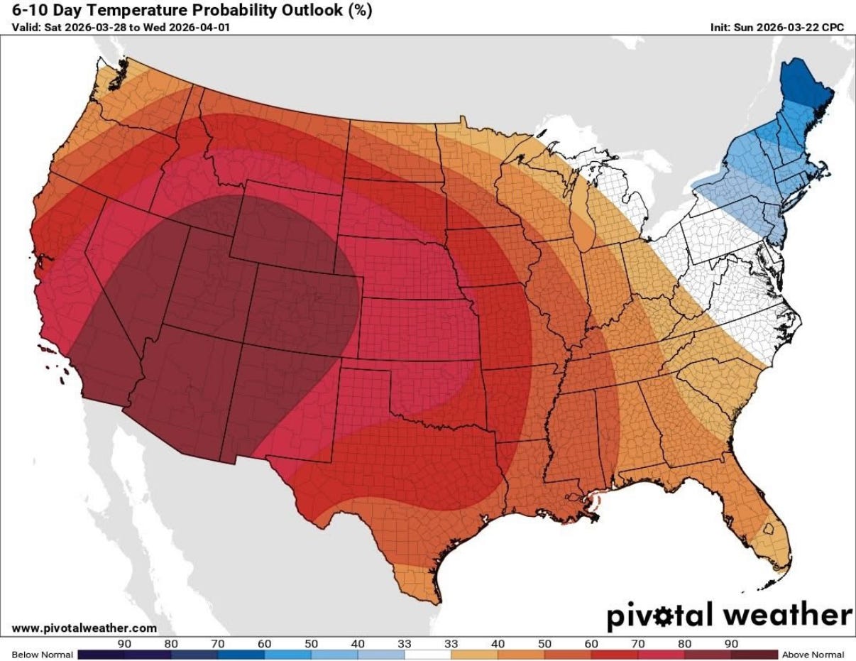
With this temperature outlook it’s likely that any remaining western snowpack will melt considerably over the next few days.
Want to stay up to date with Wilderness? Make sure to subscribe.
Have a question or something to add? Leave a comment.
https://www.yahoo.com/news/articles/trump-administration-cuts-key-california-120000364.html